CapeLinks Cape Cod Massachusetts
Cape Cod Maps & Satellite Images - Aerial Photos, GPS Lat/Long Tools
All of our maps & geocoding tools are focused in on the Cape Cod, Massachusetts USA area, but most of the maps and the GPS coordinate tools will work anywhere in the world. Just zoom out to see the world map.
Geocoder Map & Tools Get GPS coordinates (latitude & longitude) for any known street address or placeGPS Street & Satellite Map Get GPS coordinates for any location using street & satellite maps. Gives the most accurate lat/long coordinates of all our maps.
Aerial Imagery and Birdseye Views Aerial images and birdseye views as well as road and hybrid maps.
Street Map w/ Local Business Search Street map with yellow pages search overlay with relative distance and GPS coordinates for each listing
GPS Waypoints & Maps Thousands of places on Cape Cod with latitude & longitude coordinates, maps and driving directions.
GPS Topo & Aerial Photo Map Topographic and aerial image with satellite and street maps
Article Map Mapped places with articles written about them
Lodging Map Find Cape Cod lodging locations
Cape Cod Town Map: (click on the town name to view detailed maps)
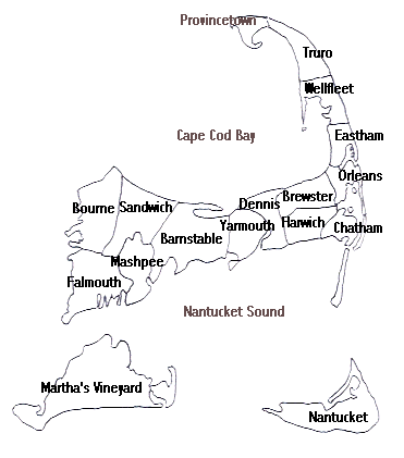
Cape Cod's towns include: Barnstable, Brewster, Bourne, Chatham, Dennis, Eastham, Falmouth, Harwich, Mashpee, Orleans, Provincetown, Sandwich, Truro, Wellfleet, Yarmouth, Martha's Vineyard and Nantucket. All of our Cape maps can be dragged and zoomed to show any part of Cape Cod, Martha's Vineyard or Nantucket as well as Plymouth, Boston and the rest of the world.


